Dr. Richard Terry, Department of Plant & Wildlife Sciences
Many of the activities of the ancient Maya did not leave artifactual or architectural remains for us to study, since many activities involved organic materials that were biodegraded over time. Furthermore, the warm and humid climate accelerated the decomposition of most organic materials (Dahlin et al., 2007). However, minerals like phosphate contained in food and other organic materials are fixed on the soil surface, imprinting a chemical trace which is possible to analyze (Barba and Ortiz 1992; Terry et al. 2000; Parnell et al. 2001). Geochemical techniques can be used to determine ancient human activity and their correlation to minerals like P, Fe, Cu, Zn, and Mn. Moreover, the geochemical results from these analysis can be spatially analyzed to define the places the activities took place.
Since all plant and animal foodstuffs contain P, its presence in soils and floors at elevated concentrations has been adopted as a proxy for ancient food preparation, consumption, and disposal areas. Other minerals, like Zn, are also correlated with P concentrations at these activity areas (Dahlin et al. 2007).
The objective of the mentored research was to use P prospection as a tool to locate ancient midden features at household groups at Tikal, Guatemala and at Wolf Village in Utah County. High P concentrations might indicate the places where past inhabitant discarded quantities of foodstuffs, broken ceramics, along with wood ashes and charcoal.
Methods – Chemical Analysis
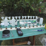
We used the following procedure to extract and analyze soil phosphorus: 2 g of soil are mixed with 20 ml of Olsen Bicarbonate extraction solution (0.5 M NaHCO3 at pH 8.5), using 50 ml jars attached to a board to analyze six samples at a time. Then, the samples are shaken for 30 minutes, after which they are filtered through a 15 cm filter paper, collecting the filtrate in a similar gang of six 50 ml jars. After that, 1 ml of the solution is aliquoted to a colorimeter vial and diluted to 10 ml using deionized water. A packet of PhosVer 3 Reagent is added to each sample, shaken for 60 seconds, and let to rest for four minutes for color development. Finally, the samples are measured with a Hach DR/850 Colorimeter, using the % Transmittance function. More information about the modifications in the method can be found in Terry, et al. (2000).
Grids of 10m intervals were established by mean of flags and measuring tapes. Soil surface samples of 0-10cm were collected by trowel following the removal of the leaf litter layer.
Results and Discussion
Phosphate prospection studies were conducted at the ruins of Tikal, Guatemala in February and March of 2010. Additional prospection studies were conducted at Wolf Village near Goshen, Utah in July. The results of those studies are presented below.
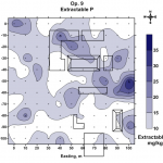
The 10×10 m grid included a major patio group of four structures in the northeast area of Operation 9. A patio group with smaller structures was located in the southeast corner of the Operation. The P concentrations in that patio were very low, in the range of 5-10 mg/kg. The highest P concentration (ca. 25-36 mg/kg) was found in the east side of the Operation between the two patio groups, suggesting a shared midden deposit. A number of “hot spots” or high P areas are visible in Figure 2, and their significance might be confirmed by archaeologists working on the area. The background P concentration of 5 mg/kg was determined by averaging 10 percent of the samples lowest in concentration.
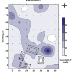
Four minor structures and a small patio were found at the south end of Operation 13 (figure 3). On the southeast side of the patio group there is an area of high P concentration of ca. 40-58 mg/kg, while the background P concentration was about 9 mg/kg.
There is a pattern of elevated P concentration starting at the area of higher levels (58 mg/kg), and moving to the center, then to the northwest corner of the grid. The P levels represented in this pattern are ca. 20-30 mg/kg.
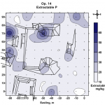
The patio group in Operation 14 (Figure 4) consisted of several elite structures surrounding a large patio. Smaller structures were found outside the patio group. A remarkably large patio surrounded by four structures is visible in the center of Figure 4. One area of high P concentration is found at the north end of the patio at the corner of the staircase of the north structure. Other areas of high P are to the west of the large patio near smaller structures. The higher P values are in the range of 40-60 mg/kg. The background P level in Operation 14 was 7 mg/kg.
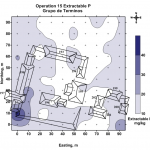
The Terminos reservoir group is located in a heavily vegetated area on Puleston’s east transect (Puleston, 1983). A group of 10+ workers were necessary to cut down the vegetation in order to take soil surface samples. In Operation 15, a number of structures constituted a large patio group on the west side and a smaller patio group on the east side (Figure 5). P concentrations of ca. 45 mg/kg were found in only one area, on the southwest corner of the larger patio group. Background P levels were about 10 mg/kg.
In the course of two weeks we were able to analyze 383 surface soil samples in the field laboratory. The field laboratory allowed for timely analysis of soil samples to provide data to archeologists while the excavations were still open.
This study demonstrates the utility of geochemical analysis for the archaeological study of activity areas for the site Wolf Village. Geochemical studies help to evaluate the correlations between archaeological data and soil chemical data, which can then be applied to archaeological situations. The high concentrations of phosphorus are likely due food processing and waste.
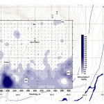
The high concentrations of Cu and Fe are indicative of the ancient use of paints and pigments. There is evidence of the use of Iron Oxide (Ochre) and Copper pigments on pottery found at the Wolf Village. The phosphorus and trace metal concentrations identified potential activity areas as well as reinforce those already known. For instance, the feature labeled F5 is a structure that is currently being excavated where there are high levels of P, Cu, and Fe. An example of an area for potential excavation for archaeologists is located at approximately 410E, 370N, because at this location of Wolf Village the levels of P as well as Cu and Fe were much higher than background levels. Geochemical and geostatistical analysis are useful tools in determining activity areas for ancient sites for further investigations in archaeology.
References Cited
- Barba, L. and Ortiz, A. 1992 Análisis químico de pisos de ocupación: un caso etnográfico en Tlaxcala, Mexico. Latin American Antiquity 3:63-82.
- Dahlin, B. H., Jensen, C. T., Terry, R. E. , Wright, D. R., and Beach, T. 2007 In Search of an Ancient Maya Market. Latin American Antiquity 18(4):363-385.
- Parnell, J. J., Terry, R. E., and Golden, C. 2001 The use of in-field phosphate testing for the rapid identification of middens at Piedras Negras, Guatemala. Geoarchaeology: An International Journal 16:855-873.
- Parnell, J. J., Terry, R. E., and Nelson, Z. 2002a Soil chemical analysis applied as an interpretive tool for ancient human activities at Piedras Negras, Guatemala. Journal of Archaeological Science 29:379-404.
- Puleston, D. E. 1983. Tikal Report No. 13 The Settlement Survey of Tikal. Philadelphia, The University Museum, University of Pennsylvania.
- Terry, R. E., Hardin, P. J., Houston, S. D., Jackson, M. W., Nelson, S. D., Carr, J., and Parnell, J. 2000 Quantitative phosphorus measurement: A field test procedure for archaeological site analysis at Piedras Negras, Guatemala. Geoarchaeology: An International Journal 15:151-166.

