Richard E. Terry, Plant and Wildlife Sciences
Mentored undergraduate students:
- Jacob Horlacher
- David Kotasek
- Benjamin Hawkins
- Tayte Campbell
- Austin Ulmer
- Adam Parker
- Bryce Brown
- Michael Barker
- Nic Goches
- Brynna Nelson
- Andrew Jenson
- Jared Barksdale
- Braden Harter
- Kevin Ricks
- Kalob Williams
- Josiah Johns
- Ian Blackwelder
- Todd McComber
- Michael Moore
- David Shurtz
- Austin Pearce
- Justin Babbel
- Paul Hosford
For the past two years, Richard Terry, his graduate students, Zachary Larsen and Jacob Horlacher have mentored twenty two undergraduate majors in Environmental Science in the collecting, preparation, and analysis of soil samples from the rural surroundings of ancient Maya cities in Guatemala and Mexico. Corn (called maize in Mesoamerica) has been very important to both the ancient and contemporary Maya. The Maya creation story as recorded in the Popol Vuh tells of the creation of man from the ground maize. Many of the Maya view themselves as “people of the maize”. The actions of planting the seeds, harvesting, preparation and even consumption of the maize are considered sacred rites.
Maize has been and continues to be the major staple crop the Maya depended on. Maize is a “super crop” with a highly efficient “C4” photosynthetic system that allows the plant to grow rapidly and to provide high yield. The trees and vines of the subtropical forest of Mesoamerica possess a less efficient photosynthetic system that is highly discriminatory against CO2 containing the heavier but nonradioactive 13C isotope. C4 maize crops are less discriminatory toward heavy 13CO2 than are the C3 photosynthetic systems of forest vegetation. C3 and C4 plants assimilate different amounts of stable C isotopes as they incorporate CO2 into their plant tissues, resulting in unique isotope ratios. These characteristic ratios are, in turn, transferred to the soil organic matter as plant tissues decompose. The decomposed crop residues and roots incorporated into the soil organic matter become recalcitrant humic substances that are preserved in the soil. In an ecosystem normally dominated by C3 plants, a long period of agricultural clearing and C4 maize cultivation can be detected by examining the relative abundances of stable C isotopes within soil profiles. Soil organic matter that was derived from decayed plant remains, contains a history of the dominant vegetation types. Over the past decade soil scientists have used the ratios of 13C to 12C in the soil organic matter as find evidence of past forest clearance and ancient maize agriculture in the Maya area of southern Mexico and Central America (Balzotti, et al., 2013, Balzotti, et al., 2013, Burnett, et al., 2012a, Burnett, et al., 2012b, Fernandez, et al., 2005, Johnson, et al., 2007, Johnson, et al., 2007, Sweetwood, et al., 2009, Webb, et al., 2004, Wright, et al., 2009).
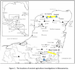
The purpose of the MEG proposal submitted in 2012 was to obtain funds to support the travel, wages, and analytical expenses for BYU Environmental Science undergraduate students to participate in ancient agricultural resources research in collaboration with archaeologists and geographers at the Maya sites of Uci, Ucan’ha, and Xuenkal in Yucatan, Mexico; Blue Creek, Belize, and Tikal, Guatemala (Figure 1). The research in northern Yucatan proceeded in the spring of 2013 and the results are complete. Mentored undergraduates Ben Hawkins and Tayte Campbell collected 99 soil horizon samples from 29 soil pits. They were assisted by other mentored undergraduates in the analysis of those samples. Archaeological permits for work at Tikal were delayed for one year. In the spring of 2014 undergraduate Adam Parker collected 116 soil horizon samples from 32 soil pedons at Tikal. Graduate student Austin Ulmer and undergraduate Bryce Brown collected 124 horizon samples from 17 soil profiles near Blue Creek, Belize by. Those samples are currently being analyzed for chemical characteristics and carbon isotope ratios in Dr. Terry’s soil geochemistry laboratory. Only a few preliminary results are available from the Guatemala and Belize samples for this report.
Materials and Methods
Samples were collected and stored in Whirl-Pak plastic bags and shipped back to Brigham Young University in accordance with our USDA soil permit. The samples were air dried and crushed by mortar and pestle to pass a 2mm (10 mesh) sieve. A subsample (5 to 7g) were further crushed to pass a 60 mesh (0.25mm) sieve. Dry color was assessed with the aid of Munsell color charts and pH was measured by glass electrode on a 1:1 soil to water mixture. Texture was determined by hydrometer method (Gee and Bauder., 1986). Total N, and total C were determined by dry combustion (Leco analyzer) and carbonate C was determined by titration following treatment with standard HCl. Carbon isotopic ratios were analyzed on the humin fraction of the soil organic matter. The isotopic signature of forest clearance for ancient maize crops of the Maya can be detected by changes in the carbon isotopic ratios at various depths of the soil profile. Decomposition of maize residues and root exudates incorporate elevated levels of 13C to the soil organic matter in comparison with the highly depleted 13C deposited by forest vegetation. In preparation for mass spectrometry analysis, soils went through a humic and fulvic acid extraction procedure developed by Webb and colleagues (2004) and modified by Wright and colleagues (2009) Three grams of 60 mesh sample were acidified with 20 mL of 1.0M HCl in a 70oC shaking water bath for 2 hours or until effervescence ceased. This process was to eliminate calcium and magnesium carbonates, which react with the HCl to give off CO2. Samples were then transferred to 50 ml centrifuge tubes and centrifuged at approximately 20,000 x g and the supernatant was poured off. The samples went through a cycle of two washings with distilled water and three humic acid extractions with alkaline pyrophosphate (0.1M NaOH + 0.1M Na4P2O7). The clays were highly dispersed by the sodium, therefore samples were centrifuged at approximately 38,000 x g for two hours to separate the clay from the supernatant. Extract and wash solutions were disposed after each of three extractions and three additional washings with dilute phosphoric acid to lower the pH and then with water. Samples were to air dried then oven dried at 105o C overnight and crushed to a fine powder. Isotope ratio analysis were conducted by isotope ratio mass spectrometer coupled with an elemental analyzer.
Results- Xuenkal
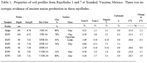
Xuenkal is a significant Maya site with a large ceremonial district and individual house lots that were built on the upper edges of ten large sinkholes (“rejolladas” in local Spanish). Several samples were collected from 2 specific rejolladas thought to been used as agricultural land. Rejollada 1 is a large and relatively shallow-slopping sinkhole with the largest pyramid at its lip. Three separate profiles were sampled, either by pit excavation or by bucket auger to a maximum possible depth.
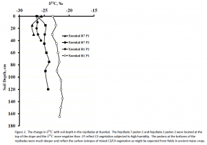
Soil profile R1P1 was excavated to a depth of 2m. The isotopic signature of this profile reflects mixed C3/C4 vegetation that has predominated the region since the time the Maya first cleared the rejollada for maize production (Figure 2). Profiles R1P2 and R1P4 were taken on the backslope within ancient gravel terraces bordering the lip of the rejollada. This particular rejollada was selected because of its size and proximity to the main city-center. The potential to use this as an agricultural resource appeared to be great. However, by examining the stable carbon isotopic signatures of R1P1 from surface to depth (Figure 2), we see little to change in the δ13C. Carbon isotopes were about -23‰ at the surface, with a small shifting toward -21‰ from 30cm to 130cm. However the δ13C of all the horizons in R1P1 were between 3.5 and 5.5‰ more positive than the horizons of R1P2 and R1P4. The difference in δ13C is 5.5‰ – strong evidence of ancient maize agriculture with subsequent mixed vegetation to the present. Samples R1P2 and R1P4 show no significant changes, or shifts, in signature and provide evidence that the terraces around the slopes of the rejollada were mainly used in C3 vegetation – perhaps orchard crops.
Rejollada 7 is located 300m to the South and west of Rejollada 1. It is no more than 50m across with fairly steep walls. It is currently covered in thick forest vegetation with exposed limestone walls. Two samples were taken in the bottom of the rejollada with a bucket auger. Rejollada 7 has several house mounds and structures surrounding the edges, and as such was thought to be an important resource to those who occupied the area anciently. Profile R7P1 at the top lip of the rejollada was sampled to bedrock at 30cm. . Samples in the R7P1 pedon showed a shift in δ13C from surface to 30cm from -25.6 ‰ to approximately -27.5‰ (Figure 2). Profile R7P2 was 120cm deep before bedrock was reached. This pedon showed a shift of 2.4 particularly between 45cm to 75cm. This is weak evidence that ancient maize was grown in this rejollada. The steepness of sides suggests that cacao and other crops that thrive is high humidity may have been grown there.
Uci-Results
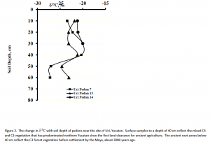
Uci is a significant ancient Maya site located approximately 3 kilometers north of the modern city of Motul, Yucatan. Fifteen soil profiles were examined and horizon samples collected along transects extending into areas thought to have been ancient agricultural fields on the east side of Uci. The 15 profiles varied in surrounding vegetation, elevation, soil depth, texture, and current land use. All samples were analyzed for stable carbon isotopes in the soil organic matter to determine if ancient Maya peoples used these lands to farm maize. Uci Profiles 7, 13, and 14 all exhibited isotopic signatures indicative of ancient land clearance and maize agriculture.
Results- Ucan’ha
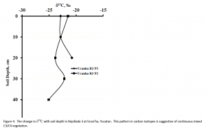
Ucan’ha is an ancient Maya site located approximately 12 kilometers east of Uci. Three rejolladas were selected to evaluate their ancient agricultural potential. Changes in the δ13C of Ucan’ha profiles R3P2 and R3P3 are displayed in Figure 4. Profile R3P2 was taken from the approximate center and bottom of Rejollada 3, while R3P3 was taken on the upward slope of the rejollada. The isotopic signature shows a slight positive trend with depth with δ13C of -23‰ at the surface to almost -20‰. Profile R3P2’s isotopic signature, however, displayed the opposite of R3P3, exhibiting a slightly negative trend with from δ13C -21.5‰ to -25‰, with a slight
Ancient Agricultural Resources at Tikal Guatemala
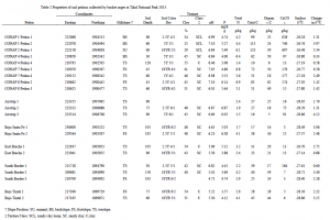
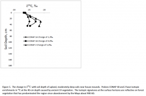
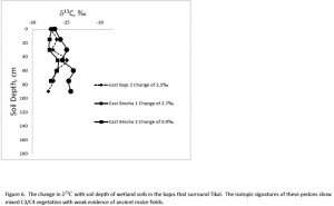
Preliminary analyses of the 116 horizon samples collected from 32 soil pedons at Tikal National Park show that shallow soils (<30cm deep) had no evidence of ancient C4 vegetation (δ 13C >2.5‰)(Figure 5). Deep soil pedons in the wetland depressions (bajos) and natural drainages had weak evidence of ancient C4 vegetation including maize cultivation (between 2.5 and 3.5‰) (Figure 6). The samples with evidence of maize production were generally enriched with CaCO3 (between 7.9% and 69.7% CaCO3 equivalent) and neutral pH. All soils sampled were low in Mehlich extractable phosphorus (< 7 mg/kg) and high in clays.
Ancient Agricultural Resources at Blue Creek, Belize
Samples were collected in Blue Creek, Belize by Austin Ulmer (MS student at BYU) and Tim Beach Professor of Geography, University of Texas, Austin) in June 2014. Seventeen profiles were collected from a transect reaching from the eastern coastal plain to the western escarpment. There were 124 horizon samples collected. All samples have been ground to 10 mesh and 5 to 7-gram subsamples to 100 mesh. During collection, charcoal samples were found in varying depths in profile RB73 footslope. C14 dating analysis provided a date of soil formation at the 93-95-cm depth of around BC 1440 and 1370. Soil physical and chemical property analyses are under way and humin extractions will be complete by October 31. Extracted samples are expected to be ground and weighed out for mass spectrometry analysis. Data is expected by December 31. Soil extractable P, color, and pH are also expected to be completed by December 31. Additional analysis will be conducted at the University of Texas-Austin in coordination with Dr. Tim Beach. Austin Ulmer will be in Texas the 17-21 of November to conduct Pb210 soil age dating, XRF (x-ray fluorescence), and XRD (x-ray diffraction) texture analysis.
Outcomes
Two graduate students and 22 undergraduate students were mentored in the planning execution, analysis of samples and interpretation of data. Several of the students travelled to Mesoamerica where they interacted with archaeologists and local Maya laborers in collecting soil profile samples. They had the opportunity to train archaeology student in field laboratory techniques of soil geochemical analysis. They worked and spoke to local laborers who assisted with the work. The students learned to interact with those of other culture and other academic disciplines. Most of those undergraduates are either in postgraduate education at this time or are planning graduate work in the next couple of years.
References cited
- Balzotti, C., C. Golden, A. Scherer and R. Terry. 2013. Stable carbon isotope signatures of ancient Maize agriculture at El Kinel, Guatemala. Central European Geology 56: 59-74. doi:10.1556/CEuGeol.56.2013.1.5.
- Balzotti, C.S., D. Webster, T. Murtha, S.L. Petersen, R.L. Burnett and R.E. Terry. 2013. Modeling the ancient maize agriculture potential of landforms in Tikal National Park, Guatemala International Journal of Remote Sensing 34: 5868-5891.
- Burnett, R.L., R.E. Terry, M. Alvarez, C. Balzotti, T. Murtha, D. Webster and J. Silverstein. 2012a. The ancient agricultural landscape of the satellite settlement of Ramonal near Tikal, Guatemala. Quarternary International 265: 101-115.
- Burnett, R.L., R.E. Terry, R.V. Sweetwood, T. Murtha, D. Webster and J. Silverstein. 2012b. Upland and lowland soil resources of the ancient Maya at Tikal, Guatemala. Soil Science Society of America Journal 76: 2083-2096. doi:Doi:10.2136/sssaj2010.0224
- Fernandez, F.G., K.D. Johnson, R.E. Terry, S. Nelson and D. Webster. 2005. Soil Resources of the Ancient Maya at Piedras Negras, Guatemala. Soil Science Society of America Journal 69: 2020-2032.
- Gee, G.W. and J.W. Bauder. 1986. Particle-size analysis. In: A. Klute, editor Methods of soil analysis. Part 1. Soil Science Society of America, Madison. p. 383-411.
- Johnson, K.D., R.E. Terry, M.W. Jackson and C. Golden. 2007. Ancient soil resources of the Usumacinta River Region, Guatemala. Journal of Archaeological Science 34: 1117-1129.
- Johnson, K.D., D.R. Wright and R.E. Terry. 2007. Application of carbon isotope analysis to ancient maize agriculture in the Petén region of Guatemala. Geoarchaeology: An International Journal 22:: 313-336.
- Sweetwood, R.V., R.E. Terry, T. Beach, B.H. Dahlin and D. Hixson. 2009. The Maya footprint: Soil resources of Chunchucmil., Yucatan, Mexico. Soil Science Society of America Journal 73: 1209-1220.
- Webb, E.A., H.P. Schwarcz and P.F. Healy. 2004. Carbon isotope evidence for ancient maize agriculture in the Maya lowlands. Journal of Archaeological Science 31: 1039-1052.
- Wright, D.R., R.E. Terry and M. Eberl. 2009. Soil properties and stable carbon isotope analysis of landscape features in the Petexbatún region of Guatemala. Geoarchaeology: An International Journal 24: 466-491.

