Tayte Campbell and Dr. Richard Terry, Department of Plant and Wildlife Sciences
Introduction
The ancient Maya were one of the largest civilizations in Mesoamerica and were spread over a large geographic area. A large population of ancient Maya lived in the northern lowlands in an area now known as the Yucatan Peninsula. Soil resources in the Yucatan Peninsula generally consist of shallow clay soils that would have made it difficult for the ancient Maya to conduct sufficient agriculture to feed their large population.
The landscape in the Yucatan is caused by karst geology. This consists of limestone outcrops as well as depressions caused by the dissolving and collapsing of the limestone bedrock. These depressions are called rejolladas. These rejolladas provide areas for soil to accumulate making them likely areas for agriculture.
Methodology
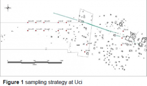
At Uci we divided the project into four categories or sampling schemes as can be seen by the labeled red dots in Figure 1. The first sample grouping (Uci w1 – Uci w3) is located just to the West of the site center in an area that is curiously devoid of architecture. The second grouping (Uci w4 – Uci w5) is located further West near a house mound. The third grouping (Uci w6 – Uci w9) is located on the inside edge of the site boundaries. The fourth and final grouping (Uci w10 – Uci w15) is located outside the site boundary in vacant terrain.


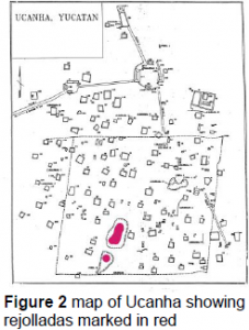
At Ucanha we tested the rejolladas that are marked red in Figure 2. We took samples at the center of each rejollada as well as on the edges surrounding the rejolladas.
At each of the sites indicated we dug pits and collected samples every 10 cm. In the lab, each sample was air dried, ground, and passed through a 10 mm mesh to remove rock and gravel. Dry Munsell color was taken. The pH was determined using a 1:1 soil to water mixture by glass electrode. Soil texture was calculated using the hydrometer method (Gee and Bauder, 1986).
Results
Uci
The soil depths were shallow. Only two pits, pit 7 and pit 13, were deeper than 30 cm, reaching a depth of 60 cm. The pH of all the samples was slightly basic, most likely due to the limestone bedrock. The soil texture was predominately clay, the only variation being pit 6 with a texture of clay/clay loam.
Ucanha
Soil depths at the center of the rejollada were deeper than those at the edges of the rejolladas. This shows that the rejolladas were areas where soil accumulated. The pH of the samples was slightly basic. The soil texture was predominately clay, the only variation being one pit with a texture of clay/silty clay.
Discussion
Soils in Uci are typical of karst topography, namely shallow, clay soils. These shallow soils would have made it difficult for the ancient Maya to grow enough food to support their large populations. We are currently working on further analysis of carbon isotopes in order to identify the areas where maize was grown anciently. Corn leaves a distinct carbon isotope in the soil that can be identified through chemical tests. This further isotope analysis will let us know if the areas that we have tested were indeed used for maize agriculture.
Conclusion
The rejolladas at Ucanha provided likely areas for agriculture because of their increased soil depths. Further carbon isotope analysis needs to be completed in order to have better insight into whether ancient maize agriculture actually occurred in these areas.
Literature Cited
- Gee G.W., Bauder. J.W. (1986) Particle-size analysis., in: A. Klute (Ed.), Methods of soil analysis. Part 1, Soil Science Society of America, Madison. pp. 383-411.
