Samuel Sorber
Abstract
Measurement of fracture sets and small-scale folds along the backlimb of the Miners Mountain uplift in the northern portion of Capitol Reef National Park reveal a paleostress direction of approximately 20° azimuth, nearly 45° counterclockwise from the principle stress observed by Bump and Davis (2003). Slickenlines along the plane of a major fault across the hinge of the Miners Mountain uplift reveal right-lateral oblique-normal movement along the fault. This information has potential significance in modeling basement involvement as well as the kinematic development of this uplift.

Introduction
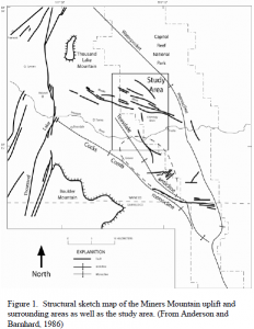
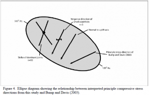
The Miners Mountain uplift is located in the northern portion of Capitol Reef National Park on the western edge of the Colorado Plateau. Although historically depicted as the northern expression of the Circle Cliffs uplift, together forming the “Waterpocket Fold,” detailed structural analysis (Anderson and Barnhard, 1986, Davis, 1999, Bump and Davis, 2003) has shown the Miners Mountain uplift to be a distinct structure, meeting the northern tip othe Circle Cliffs uplift in the vicinity of Sheets Gulch. Similar in gross morphology and Laramide tectonic origin to the nearby Circle Cliffs uplift and the San Rafael Swell, Miners Mountain is a basement-cored uplift creating an asymmetrical, doubly-plunging anticline. The gently-dipping (~15°) backlimb rises from Highway 24 near Park Headquarters (Fig. 1) flattening to form the top of the topographic Miners Mountain, with the steeply-dipping forelimb expressed by the Teasdale Monocline (also referred to as the Cockscomb Monocline in Anderson and Barnhard, 1986) which is cut along much of its length by the Teasdale fault. The fold axis trends 130° Az. forming a triangular outcrop pattern pointing toward the southeast where it meets the Circle Cliffs uplift. The northwestern end of the uplift terminates into Thousand Lake Mountain. Bump and Davis (2003) have proposed that the Miners Mountain uplift formed by sinistral oblique-reverse motion along a basement-cored fault; the fault trend parallel to the fold axis (130° Az.) with a principle compressive stress oriented at 65° Az., 25° clockwise from normal to the fold axis (see Figure 4).
Previous work
A great deal of classic geological research has been directed toward Laramide structures in the Colorado Plateau (Anderson and Barnhard, 1986, Billingsley et al., 1987) as well as detailed studies of Riedel deformation bands (Davis, et al., 2000, Davis, 1999, Bump and Davis, 2003) and Trishear fold modeling (Bump, 2003). These studies have constrained the fold axis and principle stress field represented by each uplift, producing a fairly complete picture of the large-scale Laramide stress regime in the Colorado Plateau. Previous kinematic studies of the Miners Mountain uplift (as well as the other related structures) are based on data gathered from the fold forelimb, with little attention given to kinematic indicators found in the comparatively undeformed backlimb, including faults, small-scale folds, and fracture sets. While data gathered from the highly deformed forelimb accurately represents large-scale stresses, backlimb structures may prove useful in better understanding the fold mechanics and possible relationships to basement structure.
Methodology
The approach used in this study focuses on mapping and determining the principle stress direction indicated by small-scale structures within the backlimb of the Miners Mountain uplift. These structures include small-scale folds, slickenlines, and fracture sets, which have been shown by Hancock (1985) and Gray and Mitra (1993) to contain reliable paleostress data.
Small-scale folds
Compressive folds have long been utilized as an indicator of paleostress, with the direction of greatest shortening representing the principle paleostress axis (σ1). Defined as small-scale folds, those used in this study are compressive, highly asymmetrical fault-propagation folds. In the study area these folds occur in competent sandstone or limestone layers sandwiched between incompetent mudstone layers, stress being accommodated by folding in the rigid rocks and by flowing in the softer rocks above and below. A compass was used to measure the direction of greatest shortening.
Slickenlines
Slickenlines, as well as other various grooves and striations found within fault planes help define the precise direction of slip along the fault. Slickenlines used in this study were found in limestones of the Permian Kiabab Formation and sandstones of the define the precise direction of slip along the fault. Slickenlines used in this study were found in limestones of the Permian Kiabab Formation and sandstones of the Permian Cutler Group within the fault that crosses the Fremont River in the southern portion of the study area (see Fig. 1). Strike and dip of each fault-plane outcrop and the rake of slickenlines and grooves were measured using a compass.
Fracture sets
Mode 1 fracture or joint sets are found throughout the more brittle portions of the Torrey and Sinbad members of the Moenkopi Formation on Miners Mountain. In a compressional regime such fractures propagate parallel to the principle stress, reliably recording paleostress in brittle rocks. Joint sets also are known to develop in extensional stress regimes, with the fracture propagating perpendicular to extensional direction. Such a stress field could also develop following the cessation of compression during relaxation of the rocks. Measurements of joint sets were made by taking the compass azimuth parallel to the fracture surface.

Field Data
Small-scale folds
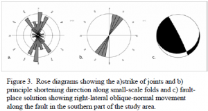
The maximum shortening directions from the measured small-scale folds are shown in Figure 3a, ranging from 190° to 212° Az.
Fracture sets
Principle stresses indicated by joint sets, shown in Figure 3b, reveal two major groupings, a larger grouping from 185° to 205° Az. and a smaller group around 330° Az.
Slickenlines
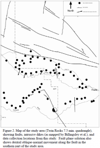
Slickenline measurements along the fault in the southern portion of the study area (see Figure 1) indicate oblique normal movement with a right-lateral component raking approximately 68° from horizontal. The fault plane solution in Figure 3c summarizes the movement along this fault.

Discussion

The fact that two distinctly different stress directions appear in the fracture data presents an initial problem. Although I make no attempt herein to explain the origin of the 330° Az. joints, a predominance of measurements trending between 185° to 205° Az. suggests that the data, although not conclusive alone, is worthy of consideration. The close match between these joint measurements and the small-scale fold vergence directions further indicates a significant pattern within this data set.
Figure 4 summarizes the data from paleostress indicators on the backlimb of the uplift compared with the principle compressive stress direction proposed by Bump and Davis (2003). The paleostress field of the backlimb indicated by the data in this study is oriented approximately 45° counterclockwise from that experienced along the forelimb, and nearly perpendicular to the axis of the uplift.
Although an in-depth investigation into this data is beyond the scope of study and will be continued in my master’s thesis, I would like to suggest here two possible explanations for this change in stress field between forelimb and backlimb.
The first and most simple explanation is that these fracture sets and small-scale folds in the backlimb did not form concurrently with the Miners Mountain uplift and represent a different stress field. This could have occurred either prior to or after the Laramide stresses, or possibly represent a rotation of the Laramide stress field.
The second explanation is that the stress of the Laramide was transmitted primarily through the basement rocks and only deformed the overlying sedimentary strata where the basement failed and a fault-propagation fold developed. In this situation, the strata on the backlimb of the fold would be, in a sense, “riding” on the basement. As the fold developed parallel to the underlying fault and oblique (55°) to the basement stress, strata with weak shear strength would create a partial detachment, allowing the sedimentary pile to become partially “unglued” from the basement. Further away from the fault, the compressive stress field would then be perpendicular to the axis of the fold, rather than parallel to the far-field stress transmitted through the basement.
Although the measurements from the fault along the hinge of the Miners Mountain uplift are not directly applicable in the previous discussion, I believe that the previously unrecognized oblique movement along the fault will have important implications for future studies of the kinematics and basement involvement of the uplift.
Acknowledgements
This work was supported by a Brigham Young University ORCA grant and undergraduate mentorship funds. Thanks to Jeremy Gillespie, and my wife Rachel for their invaluable help in the field, as well as Tom Morris, Dan Martin, and James Eddlemann for their help and review of my ideas. This work was done as a preliminary part of my master’s thesis, and will be included in a larger forthcoming structural and kinematic modeling project.
References
- Anderson, R.E., Barnhard, T.P., 1986. Genetic relationship between faults and folds and
determination of Laramide and neotectonic paleostress, western Colorado Plateau transition zone. Tectonics 5, 335-357. - Billingsley, G.H., Huntoon, P.W., Breed, W.J., 1987. Geologic Map of Capitol Reef
National Park and Vicinity, Emery, Garfield, Millard and Wayne Counties, Utah. Utah Geological and Mineral Survey, Salt Lake City. - Bump, A.P., 2003. Reactivation, trishear modeling, and folded basement in Laramide uplifts: Implications for the origins of intra-continental faults. GSA Today 13, 4-10.
- Bump, A.P., Davis, G.H., 2003. Late Cretaceous-early Tertiary Laramide deformation of the corthern
Colorado Plateau, Utah and Colorado. Journal of Structural Geology 25, 421-440. - Davis, G.H., 1999. Structural Geology of the Colorado Plateau Region of Southern Utah
with Special Emphasis on Deformation Bands. Geological Society of America Special Paper 342. - Gray, M.B., Mitra, G., 1993. Migration of deformation fronts during progressive deformation: evidence
from detailed structural studies in the Pennsylvania Anthracite region, USA. Journal of Structural Geology 15, 435-449. - Hancock, P.L., 1985. Brittle microtectonics: principles and practice. Journal of Structural
Geology 7, 437-457.
