Stephen H. Alfandre and Dr. Richard Jackson, Geography
The City of Zion is something that is commonly discussed but rarely conceptualized. The only information we have pertaining to the spatial characteristics of Zion is a plat created by Joseph Smith in 1833. And although the plat revolutionized city settlement in the western United States, there are still many unanswered questions about the design relating to the overall masterplan for the City of Zion. It does not address the regional plan, open space, parks, or transportation, which are all vital to the planning and building of any city or town.
In an attempt to answer some of these questions, I studied some of the best examples of planning and design in the world. I traveled to England to study Garden Cities, Spain to observe the church plazas, and France to understand city structure. I was also able to see numerous examples of superior planning all across the United States as well as converse and interface with some of the top planners, designers, and land developers in the country. It is because of this experience that I was able to create the following plan for the City of Zion.
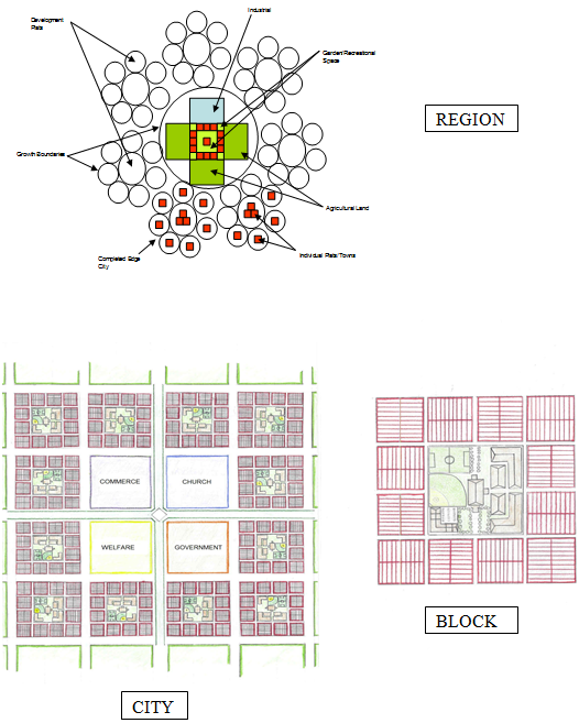
The blocks consist of five-acre mini-blocks divided into 20 lots. Each lot is one quarter acre in size and each mini-block houses between 100 – 150 people. Grouped together are sixteen of these five acre mini-blocks into one 80 acre super block. The outside twelve blocks are the residential blocks with the inner four blocks serving as space for multi-purpose buildings and recreational uses. Each super block represents a stake in the Church with 6 wards of 2 mini-blocks each. There is also a section of the inner block area for commercial use to support the superblock.
The city consists of sixteen super blocks. The outer 12 blocks are after the model mentioned above. The inner four blocks are divided into four separate districts: 1) Church, 2) Commerce, 3) Government, and 4) Welfare. A temple is located in the center of the town with an uninterrupted vista extending in all four cardinal directions. The pathways of these vistas are open park strips extending to the end of the city. Directly outside of town are located the industrial and agricultural uses. There is also open space and recreational uses such as golf courses and nature walks. The town, just as in Joseph Smith’s plan will grow no bigger than 20,000 people with a growth maximum of 16 super blocks per town.
The regional plan consists of 12 town plats in a square with one main plat in the center to form a city. Agricultural land and industrial land touch the city periphery. Budding out of the city are smaller regional cities with seven individual town plats budding off from them. The 12 center plats are to be constructed first followed by the edge cities. One plat will be built at a time to control and monitor growth. There will be a transportation network linking the region together which will consist of commuter rail, light rail, and bus-rapid-transit.
This plan is designed around two fundamental cornerstones: Christ, and the Family. At the center of each city and block are temples that can be seen from all four cardinal directions with uninterupted views. It is a constant reminder that Christ remains at the center of everything. Surrounding “Christ” are the 12 residential blocks representing families in the 12 tribes of Israel. These blocks are designed so that families can learn, live, play, and worship together. They are designed for families to walk to school, church, and parks, thus promoting healthy, interactive living.
In summary, this city will be a healthy, active, safe, vibrant, sacred place where families can live together in happiness while worshiping Christ in a beautiful, peaceful, and spiritual setting.