Samuel Gilstrap and Dr. T. Leslie Youd, Civil and Environmental Engineering
The term liquefaction refers to the loss of strength in soils during earthquake shaking. Generally, liquefaction occurs in loose sandy soils which lie beneath the water table. Liquefaction-induced ground failures have been major causes of bridge damage during past earthquakes. My research was to apply state-of-the-art methods for evaluating liquefaction hazard to the bridge sites along the 1-15 corridor in Salt Lake County, Utah. This section of interstate is to be reconstructed over the next 4 years and is one of the largest construction projects ever initiated in Utah. This segment of the highway lies generally parallel to the Salt Lake segment of the Wasatch fault which is capable of moderate to large (magnitude 7.0) earthquakes. My study predicted that potentially liquefiable soils lie beneath most bridge sites in the corridor.
Utah lies in an active seismic area, capable of generating moderate to large earthquakes that could readily trigger liquefaction in susceptible sediment. The seismic study by Dames and Moore recommended a peak horizontal acceleration of 0.6 g and an earthquake magnitude of 7.0 for liquefaction hazard evaluations.
This study utilized data from recent (1996) subsurface investigations in the I-15 corridor. Cone penetration tests (CPT) were conducted at most bridge sites. Standard penetration tests (SPT), with field calibrated energy ratios, were performed at every bridge site. Elevations, coordinate locations, and water table depths were measured at all CPT and SPT locations. For this analysis, we applied state-of-the-art procedures developed by the NCEER Workshop on Liquefaction Resistance of Soils (Youd and Idriss, in press).
The procedure used for this study combines both CPT and SPT liquefaction analysis methods. The combined analyses are more accurate in determining liquefiable sediments than previous methods because the two methods mutually compensate for individual weaknesses. The synthesized CPT and SPT procedure provides a continuous profile identifying potentially liquefiable sediments from the CPT log with sporadic confirmation and measured laboratory data from the SPT. Thus, this integrated liquefaction hazard analysis procedure provides more accurate and more certain results than from using each procedure individually.
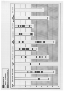
The results of this study indicate that potentially liquefiable sediments lie beneath most bridge sites in the corridor. The figure included with this report identifies the potentially liquefiable layers at some of the bridge sites in the corridor.
References
- Youd, T.L. and Idriss., in press, Proceedings, Workshop on evaluation of liquefaction resistance, Salt Lake City, Utah, January 4-6, 1996, NCEER Technical Publication, in press.

