Leo T. Brown and Dr. Alvin K. Benson, Geology
The Wasatch fault zone extends from southern Idaho into central Utah, and approximately ninety percent of Utah’s population live in or near this fault zone. Surface rupture and ground shaking associated with earthquake events represent the biggest geologic hazards to people and structures within this fault zone. Movement and rupture will most likely occur along preexisting zones of weakness or faults. In order to mitigate damage to buildings and loss of lives, the locations of individual faults within the fault zone should be determined as accurately as possible.
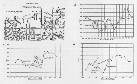
In the past, detection of faults has been limited primarily to observations of surface features and trenching of selected sites. However, many fault traces have been obliterated by geological and cultural events, and trenching is not feasible in many areas. This research focuses on fault detection using geophysical methods. Geophysical surveys were conducted to map and characterize concealed faults in east Provo, Utah along the Wasatch front. Gravity and magnetic data were collected along nine different traverses (Fig. 1) at 344 stations and were processed using conventional techniques. Accuracy in these data was maintained by returning to a base (reference) station every two to three hours to tie all the data together and by repeating readings at numerous stations from time to time. Ambiguities in the interpretations were reduced by (1) incorporating data from previous geophysical surveys, including seismic data, surface mapping, and well data; (2) integrating the gravity and magnetic data; and (3) correlating the interpreted data.
Four larger faults located approximately one-quarter mile west of the main Wasatch fault were mapped in three dimensions. Two of these faults are oriented in the same direction as the Wasatch fault (Water Tank fault and Willow Lane fault, Figs. 2, 3, 4), while the other two are oriented opposite to the Wasatch fault (Oak Lane fault and Antithetic Water Tank fault, Figs. 2, 3, 4). Based upon observations of surface features only, portions of the Water Tank, Willow Lane, and Oak Lane faults were previously mapped,1 and some of the subsurface characteristics of these faults were estimated near Rock Canyon using geophysical methods.(2,3) Excellent correlation exists between those data, trench data along Rock Canyon Road (2300 North), and the interpreted data from this research project. In addition, the geophysical surveys in this project extend the subsurface mapping of the Water Tank, Willow Lane, Oak Lane, and Antithetic Water Tank faults over 1,200 feet farther north and over 300 feet farther south than previously mapped. The integrated interpretations give a stronger likelihood that the interpreted faults are actually there.
Information derived from this study will be useful for further planning and development of areas within the Wasatch fault zone, and more geophysical data, particularly seismic, will be collected in the east Provo area in the future. The characteristics of subsurface deformation can be used to gain a better understanding of the potential for surface faulting at a given site. This is also useful in planning appropriate site development and remedial measures to help mitigate hazards associated with large-magnitude earthquakes.
References
- Hintze, L.F. 1978. Brigham Young University Geology Studies, Special Publication 5.
- Benson, A.K., and Mustoe, N.B. 1995. Engineering Geology 40:139-156.
- Benson, A.K., and Mustoe, N.B. 199 1. Quarterly Journal of engineering Geology 24: 375-387.
- This research was supported by the Office of Research & Creative Activities and the College of Physical and Mathematical Sciences, Brigham Young University.
Figure 1: Locations of the nine geophysial survey lines along the Wasatch front in east Provo, Utah
Figure 2: Interpreted gravity data along line 6 (2300 N). The Wasatch, Water Tank, Willow Lane, Oak Lane, and Antithetic Water Tank faults were all mapped along this line.
Figure 3: The interpreted gravity data along line 1 (Iroquois street) maps the Water Tank, Willow Lane, Oak Lane, and Antithetic Water Tank faults, extending these faults over 1,200 feet north of previously mapped locations.
Figure 4: The interpreted gravity data along line 9 (1850-1950 N) maps the Water Tank, Willow Lane, Oak Lane, and Antithetic Water Tank faults, extending these faults over 300 feet south of previously mapped locations.

