
Taylor McDonnell and Tim McLain, Department of Mechanical Engineering
Introduction:
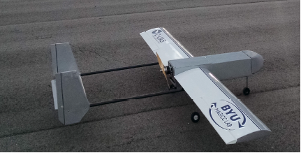
Figure 1: BYU AUVSI Competition Plane
Commercial applications of unmanned aerial systems (UAS) are expected to grow
significantly in the coming years [1]. Applications of unmanned aerial vehicles in the
commercial market include agricultural and infrastructure monitoring, aerial
photography, package delivery, fire monitoring, wildlife tracking, and search and rescue
operations. One of the purposes of the AUVSI-SUAS
competition is to train undergraduates for the growing
UAS industry. In this competition a team’s UAS must
autonomously identify and locate several targets, which
are geometric shapes with a given shape, shape color,
letter, letter color, geolocation, and orientation. The
focus of this project is to develop the image processing
and geolocation software necessary to participate in this
competition.
Methodology:
Our approach to autonomously identify and classify targets includes several phases. At
each phase additional information is bundled with the image and passed to the next
step for further processing. This framework is accomplished using a set of software
libraries and tools called ROS.

Figure 2: Illustration of Image Processing Process
The first phase of our image processing is image correction. The geometric shapes
which represent the targets in this competition are simple 2D shapes, but when seen at
any angle other than straight down from above these shapes become distorted. The
image correction step removes this distortion. In this phase, the geolocated location of
each corner is used to transform the image to appear as if the UAS is directly over the
target.
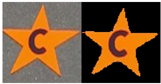
Figure 3: Example target before
and after image filtering
After the image correction phase, the image is filtered to identify large contiguous
portions of the same color. These regions (or blobs) are identified as potential shapes
and the contours of these blobs are extracted to be analyzed.
In the shape detection phase, metrics of each blob, such as
the ratio of perimeter to area, are compared with metrics of
potential shapes [2]. When a blob’s metrics match a shape’s
metrics within a specified tolerance, the blob is identified as
that shape. If no shape is assigned, the blob is rejected as a
potential target.
Letter detection is performed using Tesseract, an open source optical character
recognition engine. Before using Tesseract, all parts of the blob are filtered except the
letter itself. The image is rotated and Tesseract is run at different angles to determine
both the character and the direction in which the target is oriented.
The last phase of image processing, geolocation, is performed using geometric relations
obtained from the UAS autopilot and gimbal [3].
Results:
Preliminary results for this project have shown good promise. Since switching to the
current color-based image filtering technique, filtering is quicker and more reliably finds
potential targets. Letter detection, after adding preprocessing, has a high success rate
of predicting the correct alphanumeric character. The shape detection method has
been shown to work, but has potential for improvement. The image correction and
geolocation phases require validation and will need to be tested.
Discussion:
The purpose of the AUVSI competition was to train students for the growing UAS
industry. This project has successfully done that. Several lessons have been learned
from participating in this project. A few are presented here:
- Leverage all accessible information. Our current and most effective blob
detection technique works because it is simple, customized to our individual
targets, and uses more available image information than other techniques. - Having an effective software organization method greatly aids systems
integration. Using ROS enabled us to have a parallel work-flow and allowed us
to try many different image processing techniques without having to change
many portions of the code. - While good for combining elements into the final software package, ROS was not
good for conceptual development. It is suggested that conceptual development
be done in a user friendly coding language/environment such as MATLAB before
implementing within the final software structure. - Testing is nontrivial. The image processing process presented here requires
information from the autopilot, gimbal, and camera in real time in order to work.
Thus test flights dedicated to image processing need to be carefully planned in
order to validate the developed code
Conclusion:
While our AUVSI team was not prepared to compete in the AUVSI-SUAS competition
this year, we developed a strong foundation for future teams to build upon. With proper
testing a debugging next year’s team should be able to represent BYU well at next
year’s competition.
Sources:
[1] Weissbach, Dyveke and Tebbe, Kathryn. Drones in sight: rapid growth through M&A’s in a soaring new
industry: Strategic Direction: Vol 32, No 6. (2016). Strategic Direction, 32(6), 37-39.
[2] Jorge, J. & Fonseca, M. (2000). A Simple Approach to Recognise Geometric Shapes Interactively.
Graphics Recognition Recent Advances, 266-274. http://dx.doi.org/10.1007/3-540-40953-x_23
[3] Barber, D., Redding, J., McLain, T., Beard, R., and Taylor, C. (2006). Vision-based Target Geo-location
Using a Fixed-wing Miniature Air Vehicle. Journal of Intelligent and Robotic Systems, 47(4) 361-382