Forrest Minor and Dr. David Long, Electrical and Computer Engineering
Introduction
Microwave scatterometers, which use radar backscatter measurements from satellites to infer wind vectors near the ocean’s surface, have the ability to monitor global wind speeds at high resolutions. Such data is used for weather forecasting and climate research. However, scatterometer observations over the ocean can be contaminated by land proximity. Consequently, current methods do not use measurements within 30 km of the coast (about 10.6 million square kilometers worldwide) in the data set. This unused data can be utilized by a recently developed algorithm that can measure winds as close as 5 km to the coast (Owen and Long, 2009). Here the author shows that areas near land can be systematically targeted for special processing using information from L2B files, providing valuable near coastal wind data. To demonstrate the effectiveness of the targeting method on a global scale, a sample 4-day data set is processed.
Methodology
In order to decide what data should be processed, each satellite orbit swath or pass is broken into large regions where it can be quantified whether or not a given region should be examined more closely. Since data at high latitudes are not processed, track indexes 1-112 and 1513 – 1624 are excluded from all swaths (indexes 1-113 and 1512-1624 are always high latitude estimation). This leaves an even 1400 along track rows that can be evenly divided into 14 regions that are 100 along track x 76 cross track.
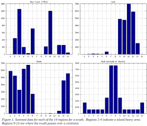
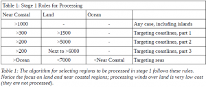
For each region, the number of cells that are land, near coastal (255 km from land), or invalid (high latitude or near swath edge) are summed (See Figure 1). This data is used in two stages to determine if a given region should be processed. In stage one, each region’s sums of land, near coastal and ocean cells are examined to determine if a given regions should be processed. Rules for stage 1 are established based on correlation between the summed data for several swaths and where they fall on the map. In the second stage, adjacent regions are combined and then are extended or reduced (in along track size) based on the presence of near-coastal cells at the edges of the new region. The results from stage two can be used as inputs to process the data using the LCR code.
To test this method, an arbitrary 4-day sample data set was selected from 2007, Julian Days 133-136, 2007 (comprised of 57 complete swaths). QuikSCAT covers about 90% of the earth’s surface daily, but it only repeats every 4 days. Using a 4-day sample set should expose the method to almost every possible case.
Results & Discussion
Observations of regional data like Figure 1 showed that certain geographical features had consistent Near Coastal, Land and Ocean sums per region (see Table 1 for observations and Figure 2 for implementation results). Interestingly, regions such as French Polynesia had the highest raw number of near-coastal cells per region, suggesting that some island regions are worth processing. However, islands vary greatly in regional sums and generally are not worth processing unless they are large or highly concentrated.
Coastline results also prove interesting. If a region has a large amount of land in it (but less than 7000, which is 100% land) it is probably a continent with a coastline, but if it is next to a region that is a continent, it is very likely a coastline. However, these coastlines often have comparatively few near coastal cells, lower than in seas or some island regions. One possible cause of this may be relatively straight coastlines. Even though these regions have fewer near coastal cells, the coast per cell is low because much of the region will be over land in these cases.
Conclusion
Overall, figures of the 57 sample swaths (from the 4 day sample) like those in Figure 2 showed that the near coastal region targeting algorithm works as expected. Near coastal regions can be targeted for special wind retrieval processing. Near coastal region data is being tested on Owen’s LCR code, preliminary results indicate that data is compatible. Future work includes producing low resolution winds for the sample set using the near coastal region data and investigating methods of publishing the wind vector data in ways wind users can easily access it.
References
- Owen, Michael, and David Long. “Land Contamination Compensation for QuikSCAT Near-Coastal Wind Retrieval” IEEE Trans. Geosci. Remote Sens.. 47.3 (2009): 839-850. Print.


