Krey H. Price, Department of Civil and Environmental Engineering
Abstract
The Bear River Migratory Bird Refuge has long been an important haven for migrating waterfowl in North America. During the wet years of 1983-84, however, the refuge was inundated and closed. The refuge has since reopened, but reconstruction of water control structures continues. The U.S. Bureau of Reclamation has requested an evaporation study as a part of the refuge’s water budget to enable more accurate calibration of inflows to and outflows from the individual ponds in the refuge. This study applied computer modeling to estimate evaporation losses from the refuge’s ponds and marshes.
Summary of Procedures and Results
A computer model developed by R. I. Morton was selected for the study. This model requires temperature, humidity, and radiation data as climatological input, so the next step involved collection of climatological data. Some data were available for the refuge itself, and unavailable data were replaced by applying average variations to records from nearby stations.
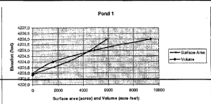
The output from the computer model is given as a depth, but for the sake of a water budget, the figures must be in volume units. Naturally, the volume of evaporating water will be the depth of evaporation times the surface area. The surface area of the refuge ponds, however, varies significantly with the depth of the pond. One of the more complicated aspects of this project was thus to develop a function that returns a surface area when given a water surface elevation. This was done by deriving depth vs. surface area and volume relationships from a contour map of the area for each of the 22 ponds. An example of such a curve is shown below:
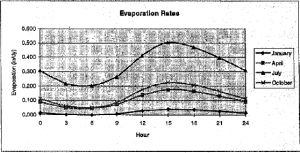
A further issue that was examined is the diurnal fluctuation in evaporation rates. Sample curves for the Bear River delta area are shown for various times of the year in the following figure:
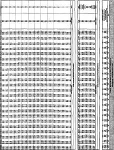
The value of this study is not in the actual figures obtained, but in the development toward a system that will use real-time automation for water control at the refuge. A spreadsheet was set up to compute volumes of evaporation for each pond given a desired water surface elevation and Morton Model output. A copy of one of these spreadsheets is included with arbitrary depths and climatological data from a sample year. The selected time interval from the model results in a slight discrepancy in the annual totals.
Evaporation losses may never become entirely predictable because of the number of variables involved. Several sources of error might reduce the accuracy of the results of this study to within about 25%, but calibration of the system after installation might correct for this error. As the reconstruction of the Bear River Bird Refuge continues, care needs to be taken to ensure that the water control problems of the past do not again endanger this fragile environment. It is hoped that this study will in some way help to preserve the valuable marshlands of the Bear River delta, so that the waterfowl can thrive in their habitat.


