Mariah Chambers and Dr. Brooks Britt, Department of Geology
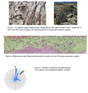
The purpose of my ORCA project is to determine the nature of the stream systems represented by the Morrison Formation, a unit of sediments deposited 150-million-years-ago (Jurassic-age) that is famed for its dinosaurs, such as Stegosaurus and Allosaurus. Despite the unit’s importance to paleontology, oil and gas exploration, and ancient stream channels on other planets, few studies of this type have been conducted (Clark and Stoker 2004). The study area covers 15 km2 near Castle Dale, Utah, where extensive exposures of the uppermost part of the Morrison Formation occur. There, ancient floodplain deposits consisting of soft clays/mudstones are easily eroded away, exposing the paleochannels (ancient stream beds) as resistant sandstone ridges (Fig. 1 & 2).
We began by mapping the exposed paleochannels (Fig. 4) in 3D using aerial stereo photos. The map enabled us to visualize, qualify, and quantify the paleochannels effectively to determine the nature of the rivers. From the 3D map, we plotted the vertical and horizontal placement of the channels to assess the changes in the river systems through time.
Measurement of meander wavelength and channel width combined with Williams’ (1988) equations revealed the average stream sinuosity to be 1.81, the paleoslope to be 0.00068, and the flow volume 200 m3/second. Compass bearings of ripples and cross-bedding in 28 paleochannels indicate an average flow direction to the northeast (Fig. 3).
In sum, the Morrison stream system in the study area consisted of isolated streams, dominated by relatively straight channels with some meandering channels. The system was extremely stable through time, as shown by there being little variation in the vertical distribution of channels. Overall, the system is typical of a foreland basin (DeCelles 1996), the predicted depositional realm (Currie 2002).
Future work will be to compare the Morrison stream systems with stream systems in overlying Cedar Mountain Formation (studied by masters’ student Amanda Sorensen (2011) to see changes over 50 Ma. Because streams are closely linked to the tectonic setting, we can see changes in the tectonics during this time period. Preliminary comparisons show there were significant changes in the regional slope causing the system to become a meandering system. In the upper part of the Cedar Mountain Formation, the paleoflow direction changes to from north-east to east-north-east.
This research has resulted in two 2012 oral presentations: the CPMS Student Research Conference and the Geological Society of America national meetings.
References
- Clarke, J.D.A., Stoker, C.R., 2011, Concretions in exhumed and inverted channels near Hanksville Utah: implications for Mars: International Journal of Astrobiology, v. 10 no. 3 p. 1-15.
- Currie, Brian S., 2002, Structural configuration of the Early Cretaceous Cordilleran foreland-basin system and Sevier Thrust Belt, Utah and Colorado: Journal of Geology, v. 110 p. 697-718.
- DeCelles, P.G, Currie, B.S., 1996, Long-term sediment accumulation in the Middle Jurassic-early Eocene Cordilleran retroarc foreland-basin systems: Geology, v. 24, no. 7, p. 591-594
- Sorensen, A.E, 2011, Geologic mapping of exhumed, mid-Cretaceous paleochannel complexes near Castle Dale, Emery County, Utah: On the correlative relationship between the Dakota Sandstone and the Mussentuchit
Member of the Cedar Mountain Formation [Master’s thesis]: Provo, Utah, Brigham Young University, 66 p. - Williams, G.P., 1988, Paleofluvial estimates from dimensions of former channels and meanders: Flood
Geomorphology. John Wiley & Sons, New York. p. 321-334.

