Erin T. Duerichen and Dr. Jeffrey D. Keith, Geology
In the Uinta Mountains, south of the South Flank Fault Zone, a thick sequence of Mississippian limestone is exposed. In the Blind Stream area, this limestone is transected by a series of north-south trending faults and fractures, with associated karsting (ie: large, collapsed cavities resulting from underground fluid migration, dissolving the carbonate rock) and calcite veining.
Recent economic interest in the area has prompted research to find an explanation of the karsing and calcite deposition. The abundance and quality of the calcite is such that it is mined and used to make figurines.
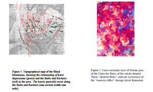
First, the relationship of the sinkhole and the fault location were determined by mapping the faults and karsts by airphoto and field observation. This information was plotted onto a topographical map using a Geographic Information Systems computer program (Arcview® Spatial Analyst). The results show that karsting was controlled largely by the fault location (figure 1).
Isotopic studies on limestone and calcite samples from the area give insight to several pertinent conditions during the calcite formation. These studies give clues about the origin of the carbon in the calcite, the age of the calcite, and the characteristics of the water that flowed through the area at that time.
The carbon isotope studies show that the calcite is most likely derived from the carbon in the host Mississippian carbonate because their carbon-13 ratios are both around +2/mil. The carbon in the underlying Proterozoic shale has a much different carbon-13 ratio.
The age of the calcite precipitation is currently being determined using the ratio of uranium and thorium to lead. For now, it is inferred that the calcite is Tertiary in age because it is younger than the Uinta Mountain uplift (early Tertiary), but it is relatively old, as manifested by many partially eroded calcite outcrops.
Isotopic study shows that the water out of which the calcite was precipitated could have been either.meteoric or briny. If it was meteoric, the water must have been cold (around 5ºC). If it was old brines, it must have been very hot water (300ºC; such a temperature is possible to reach underground because the water is confined at high pressures).
Evidence suggests that it was a hydrothermal (ie: high temperature) oil field brine that passed through this area. Underlying the carbonate sequence is the Red Pine Shale, which shows evidence of hydrothermal alteration, including pyrite and calcite deposits. These deposits extend into the Tintic quartzite beyond the South Flank Fault zone, where displacement is approximately 8000 feet. Other evidence for oil field brines include tar sands in the area, indicating oil has flowed through the area. The current model describes the possible source of the fluids and the chemical reactions taking place to produce what we now see in the rock record. Brines, possibly from the overpressurized Uinta Basin, could have swelled up along the South Flank Fault into this highly fractured area (1). The sulfate would have reacted with the constituents of the Red Pine Shale in the following way:
SO4 à H2S (reduction) C à CO2 (oxidation)
This drastic redox reaction would have increased the temperature of the area up to an estimated 300ºC. The extra carbon dioxide in the water would have increased acidity in the water, causing dissolution of the limestone above it. The fibrous nature of the calcite indicates that it formed quickly, suggesting a rapid change in the brine chemistry. If a fracture in the limestone were to reach the surface, the carbon dioxide could escape, thereby rapidly decreasing the acidity of the brine. This would cause carbonate to be oversaturated and to precipitate quickly (runaway effect – see figure 2).
References
- Nuccio, V. F., Schmoker, J. W., and Fouch, T.D., 1992, Thermal maturity, porosity, and lithofacies relationships applied to gas generation and production in Cretaceous and Tertiary low-permeability (tight) sandstones, Uinta Basin, Utah, in Hydrocarbon and Mineral Resources of the Uinta Basin, Utah and Colorado, ed Fouch, T.D., Nuccio, V. F., and Chidsey, T. C. Jr., Utah Geological Association Guidebook 20, p. 77-90.

